
Critical infrastructure operators need reliable ways to monitor assets, surrounding environments, and operational risks. This becomes more difficult when infrastructure covers large geographic areas. Bridges, power facilities, communication towers, industrial sites, and municipal assets may all require regular inspection. At the same time, the surrounding terrain and environment can change.
Traditional monitoring methods often focus on individual assets or isolated data sources. This can make it difficult for different departments to build a shared view of an area. Spatial intelligence offers another approach. It connects physical assets with geographic information, 3D models, sensing data, and intelligent analysis.
Icecypress Technology develops spatial-intelligence products and solutions based on 3D scene reconstruction, AI perception, and spatial-intelligence algorithms. Its Low-Altitude 3D Intelligent Operations Platform brings these capabilities into a broader operational framework for low-altitude applications and spatial management.
Why Critical Infrastructure Needs Spatially Integrated Monitoring
Critical infrastructure does not exist in isolation. A power facility, bridge, or communication tower is part of a larger physical environment. Terrain, nearby buildings, roads, airspace, and other infrastructure can all affect inspection and operational planning.
For this reason, infrastructure monitoring requires more than collecting information about a single asset. It also needs geographic context. A spatially integrated system can provide that context by connecting different types of data within one operational environment.
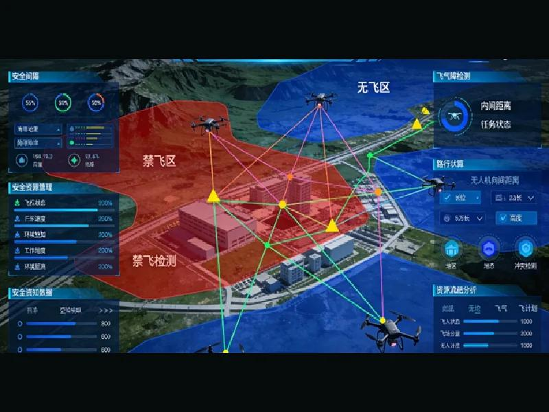
The Low-Altitude 3D Intelligent Operations Platform integrates remote sensing imagery, real-scene 3D models, airspace information, IoT sensing data, and business data. Its spatial data foundation also includes information related to terrain, buildings, bridges, high-voltage power lines, communication towers, airports or landing sites, and airspace designations.
This structure can help organizations manage monitoring information from a common spatial foundation. It can also support different departments that need to work with the same geographic area.
How an Intelligent Monitoring System Supports Infrastructure Operations
An intelligent monitoring system should do more than display collected information. It should help users understand potential risks and support subsequent operational decisions.
The Low-Altitude 3D Intelligent Operations Platform provides several intelligent analysis capabilities. These include collision-risk analysis, flight safety assessment, terrain following and avoidance, line-of-sight analysis, spatial traffic prediction, and electromagnetic environment simulation.
The platform also supports low-altitude monitoring functions. Its product information describes a monitoring process covering detection, identification, warning, and disposal. It can support simultaneous monitoring of multiple targets across frequency bands for unauthorized drone management.
For critical infrastructure operators, these functions can add spatial context to aerial monitoring. Monitoring activities can be considered alongside 3D models, airspace information, and other geographic data. This can provide a more structured basis for infrastructure inspection and risk management.
Connecting Infrastructure Monitoring With Environmental Management
Infrastructure operations can also be affected by environmental conditions. Water bodies, forests, mines, and other surrounding areas may require continuous observation. This is particularly relevant for government departments and industrial organizations managing large geographic regions.
The platform supports ecological monitoring through full-area 3D patrols of forests, mines, and water bodies. It also applies AI-based analysis to identify abnormal conditions. These functions allow the same spatial data foundation to support both infrastructure-related tasks and environmental observation.
This capability is relevant to organizations that manage several monitoring requirements at the same time. Instead of treating every monitoring project as an independent system, they can use a shared spatial environment for different applications.
For example, environmental information can be considered together with infrastructure locations and surrounding terrain. This provides additional geographic context when organizations assess operational conditions across large areas.
Supporting Smart City and Key Asset Management
Government agencies often need to manage infrastructure at a regional or city level. This creates a need for monitoring systems that can connect individual assets with broader urban information.
The Low-Altitude 3D Intelligent Operations Platform establishes a regional low-altitude “one map.” It brings together airspace, routes, flight status, landing sites, and risk information. The platform also integrates BIM, GIS, and IoT data to create a 4D spatiotemporal situation map.
These capabilities support several application scenarios. They include municipal and power-facility inspection, illegal-construction inspection, river monitoring, and intelligent protection of key areas.
The platform also supports emergency applications. These include rapid disaster modeling, rescue-route planning, coordinated multi-drone search and rescue, and priority emergency airspace access.
For smart-city projects, the value lies in connecting these functions within one spatial framework. Government departments can use the same geographic foundation for different operational requirements.
Building a Scalable Monitoring Architecture
Large infrastructure projects often develop in stages. An organization may begin with one inspection scenario and later add emergency response, environmental monitoring, logistics, or other applications.A monitoring platform therefore needs to support expansion. It should allow organizations to add applications without creating an entirely separate digital foundation for every new requirement.
The Low-Altitude 3D Intelligent Operations Platform uses a “1 Foundation + 1 Platform + N Scenarios” architecture. Its listed scenarios include urban governance, emergency rescue, logistics, modern agriculture, and tourism.The platform also emphasizes productized delivery and phased implementation. Reusable scenarios can support subsequent deployment. Continuous operations support covers areas such as data updates, maintenance, and security support.
This approach is relevant to government agencies and large enterprises planning long-term digital infrastructure. Procurement teams can evaluate not only current monitoring functions but also how the platform may support future operational needs.
Making Monitoring Data More Useful for Operations
Collecting spatial data is only the first step. Organizations also need to turn it into useful information for inspection, risk assessment, environmental observation, and emergency planning. A 3D spatial foundation can connect these data with physical locations and provide clearer context for daily operations. The same approach can support an environmental monitoring platform while linking environmental conditions with nearby infrastructure and airspace information.
As critical infrastructure becomes more connected and geographically distributed, spatial intelligence can make monitoring more practical and scalable. Icecypress Technology combines 3D data, AI-based analysis, and low-altitude capabilities to support infrastructure management. Its Low-Altitude 3D Intelligent Operations Platform provides a spatial foundation for connecting monitoring data with real operational needs.

